BRYAN TRAVIS HOOPER
May 10, 2017

An Early Semi-Urban Hike

Living in Hartford, I am usually surrounded by the trappings of an urban environment - sidewalks, asphalt, glass, steel, cars, trucks, horns honking, sirens blaring. And yet it is fairly easy to take a short drive and find oneself surrounded by wilderness. An accessible semi-urban hike is a real treasure.

One example is the hike we did last weekend. We had a pretty glorious day on our hands, so that helped. Heading west, we went to Reservoir 6 in the Metropolitan District's recreation area system. Reservoir 6 offers a wide, 3.6 mile path around the reservoir that is a real pleasure to walk on. You can get a PDF map here. Sometimes, taking a stroll around the reservoir makes for a great day.

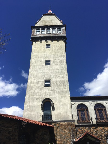
But sometimes you want something a little more. So, we walked about half way around the reservoir trail where the Metacomet Trail breaks off and heads up to Heublein Tower. Heublein is a popular destination, though the tower itself doesn't open until Memorial Day (here is the official site). There are a lot of ways to get up to the tower, but taking the Metacomet ensures a quiet hike away from the crowds.

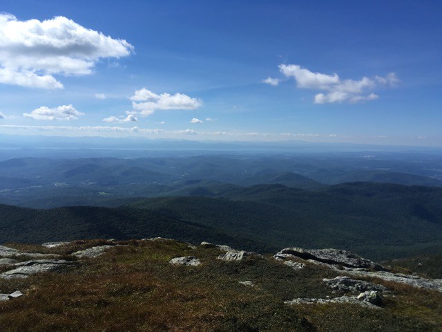
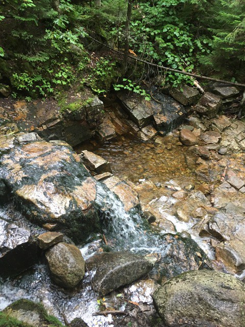
The only downside for us on this hike was that there was a lot of mud. Recent rains had really saturated the trails and in some cases getting muddy was unavoidable. But hey, that's part of the fun. Around the tower there are great views and picnic tables - a good place to chill out and hang out - and there is great space for bigger groups if you are looking for that.

Also, interesting fact: A party was once held at a large BBQ pit (which is still there) for Republican political leaders. At that event, Dwight Eisenhower was asked to run for president. A little history!

At one point, wooden boards had been placed on the ground to help navigate some muddy sections.

Another fun fact: at one place near the tower, the borders of three different towns all converge: Simsbury, Avon and Bloomfield. A sign marks the spot.

And here is the route we took. It was about 3 hours for us, moderately difficult verging on easy. We covered 6.5 miles with about 600 feet of elevation gain (and loss since we did an out and back).


Having a hike like this - that truly feels like wilderness and yet is just a few minutes out of the city - is a wonderful thing. It would be nice if more Hartfordians took advantage of this very accessible widerness.

May 2, 2017

The Uncertain Future of the UMC (and it isn't about sexuality!)

As a lifelong United Methodist and a somewhat reluctant member of the clergy, I watch the church as its institutions struggle to navigate the rough waters around homosexuality, church polity, and the demands of the gospel of Jesus Christ.

These are difficult waters to move through. For many, homosexuality remains a sin, inspires disgust, and deserves the strongest condemnation. At present, our church's official policy is to deny homosexuals (self avowed, practicing) access to full membership as clergy. The level of welcome and participation of gay and lesbian lay people varies widely from church to church (though churches are clearly moving in the direction of more acceptance of gays in volunteer roles).

So, our Judicial Council, unsurprisingly, ruled recently that a Bishop can't be a lesbian and, furthermore, our Boards of Ordained Ministry, which recommend candidates for ministry, must make a "'full inquiry' of candidates" which includes "issues of sexuality". In other words, I guess our Boards have to ask our candidates about their sex lives. That will be awkward!

What's interesting to me is that the only time the church makes news anymore is when we are fighting about homosexuality. For the vast majority of Americans, the depiction of our church in the mainstream media is the image they will retain of our church. Not a pretty picture, and not something I would want to be a part of, except that I already am.

I support the full inclusion of our LGBTQI friends in all levels of the church. If they have the gifts and grace to serve as pastors, we should be celebrating that fact. But I also think the church, on either side of this debate, is making a terrible miscalculation if it thinks that by resolving the "homosexual question" - either with a new commitment to unity or a church split - that the church's problems will somehow be easier to solve. The fact is that the world has largely moved on from this issue (Ellen came out on TV 20 years ago!) and whether or not the church "resolves" it won't be of much interest to most people.

Instead, the church - or the churches if we split - will be faced with all the underlying issues that we haven't even begun to address in earnest. We just won't have homosexuality to distract us anymore from the dismal realities of our shared life: that our churches continue to shrink, that our structures continue to be untenable, that our financial models don't add up, that our wider culture no longer understands us nor really cares about us.

So, what to do in this situation? Well, we are going to have a special General Conference, that will cost around $4 million, so we can argue some more about homosexuality.

We live in a world that is in serious turmoil and desperate need of the hope, grace, and open-ended possibilities that our God offers. The Methodists, historically, had an important role to play in extending that grace through our churches which were places for people to be accepted, loved, developed spiritually, and engaged in transformative mission and ministry. We extended that grace through our hospitals and clinics, our homes for the elderly, our schools and universities that embraced intellectual advancement and scientific inquiry. We had a passionate and progressive vision of the Gospel of Jesus Christ unfolding in our individual and collective consciousness as we pursued personal and social holiness.

What happened to that?

I fear that our church will split because I don't see how the "homosexual question" can be answered in a manner that is acceptable to all. But I fear, even more, that we will continue to fail to embrace the beautiful and worthy mission that God has given us.

August 19, 2016

Camels Hump Expedition

Editor’s Note: Though this trip took place on August 19, 2016, and the post is time stamped to reflect this date, the actual writing of this post happened on August 23.

So, after our success on Mount Willard (read all about it here), we decided to up the ante and try one of Vermont's genuine 4,000 footers - Camels Hump (height 4,083 ft.). You might think I mean "Camel's Hump", but oddly, the official name as recorded by the U. S. Board on Geographic Names omits the apostrophe, so Camels Hump it is!  Locals of course usually include the apostrophe, suggesting that the hump is owned by a camel, but I don't care! I just hiked the sucker!

We knew this one was going to be a bit more demanding. However, after reading a number of online trip reports, it sounded like we could handle it. We discovered on our journey that the hike was much harder than we expected, even after reading the reports.  It isn't impossible, by any means, but it does pose a challenge to your average hiker, with significant sections requiring four-legged scrambling and a decent elevation climb.


We planned the route above - starting off on Burrows Trail but quickly taking the Connector over to Forest City Trail. The FCT ends up at the Long Trail, south of the peak, and we took the Long Trail on up to the top.  This was by far the hardest section of trail we hiked, and where most of the scrambling occurred.  Finally, after some time on the summit, we descended back following the Burrows Trail back to where we parked.

The parking spot is located at the end of Camels Hump road.  However, be careful!! We learned the hard way that there is more than one road named Camels Hump.  So make sure you are headed to the right place.  The hike along the Forest City Trail follows a stream for bit:

After the FCT joins up with the Long Trail, things start to get a bit more challenging. Scrambling up rocks on all four is not uncommon.

A bit after some of those tough scrambles up the Long Trail you come to Wind Gap, which provides a great view through a clearing.

Some more scrambling and rock climbing - all challenging for us, but doable - resulted in a joyful rest on the summit.  One thing I will say about Camels Hump is that the summit is quite nice - wide, open with great views in all directions.  You can see Lake Champlain stretched across the land. You can see Mount Mansfield and even Mount Washington.  Spectacular views and lots of room to share the space with others. We caught a perfect day and the temperature was really nice and it wasn't too windy.  Just spectacular.

We had eaten lunch just before we reached the summit. Still the summit is a great place to dine.  The alpine region above the tree line is host to a number of fragile plant species and there are markers and signs warning you to not damage the foliage.  Generally, that was not a problem as we just stayed aware of where we were stepping.  We chilled out, absorbed the view, chatted with a few other climbers, and then began our descent, first on the Long Trail over Camels Hump and then on to Burrows Trail for the return.  Burrows is a much easier trail than the FCT, but it lacks the impressive views.  It's main perk is that it allows you to make your trip a loop, instead of an out-and-back, and it is a faster return.  If you just wanted to get up Camels Hump and get back, it would be faster and easier to just go up Burrows and back Burrows.  But that's too boring for us!

The hike took us 5 hours and 22 minutes and we covered 5.6 miles. Whew!! About 2500 feet of elevation gain and loss.  Double whew! Our 5 hour time included quite a bit of time on the summit and a few solid breaks for rest and lunch along the way.  A great day!  But we were wiped - I mean really wiped!! So a few days of rest were in our future.

Camels Hump is a challenging hike, but it provides great views and a great sense of accomplishment.

August 17, 2016

Mount Williad Expedition

Editor’s Note: Though this trip took place on August 17, 2016, and the post is time stamped to reflect this date, the actual writing of this post happened on August 23.

I like calling my hikes "expeditions" because it makes me feel awesome.  But, I am going  to reserve this word for trips that summit mountains so that it maintains it's special feel. Mount Willard (elev. 2,865 ft) may barely qualify as a mountain, but nonetheless, I'll call this an expedition.

On the other hand, there is a funny thing about the hike up Mount Willard - the trail ends just before the actual peak of the mountain.  So, technically, we didn't quite reach the summit. That said, the cliff-top area where people gather after their hike up provides spectacular views of Crawford Notch.  Since the rock face is exposed, the view are unobstructed, but so are the winds.  Though it was a warm day, the top was cold and cloudy, with lots of fog - and fierce, gusty winds that blew without ceasing.  In the cover of the forest and thus for most of the trail, the trees provided protection from the winds.

First, here is a map of the route we took:


There is a nice parking lot across 302 from Saco Lake (a handy map) just south of the AMC Highland Center and next to the Crawford Notch Station where the Conway Scenic Railway stops on it's Notch Train excursions. We witnessed the train when we retuned from our hike.  There is also a small shop and restrooms - both of which are handy.

The day was warm at our Vermont HQ, but even at the base of Willard near Crawford Notch Station the temps had dropped considerably. We were a bit concerned at the onset that we might be too cold at the top, but things turned out ok as we worked up a healthy sweat on the hike.

The trail up Willard is an out-and-back and doesn't connect to any other trails.  It does, however, start off with the Avalon trail.  After a short stint, the Willard branches to the left off of Avalon.  The Avalon trail continues southwest and eventually connects with the Appalachian Trail. The Willard hike is fairly easy, though it does climb some - we had about 1,000 feet of elevation gain in 1.5 miles up.  The total round trip was 3.4 miles and took us just about 2 hours, with a 20 minute break on the top to enjoy lunch and the view.

The trail follows a stream most of the way, and this provides opportunities for waterfalls, cascades and pools.  Plus, the pleasant rush of the running waters provides a great soundtrack to the hike.

This hike is popular, presumably because it isn't too hard and provides a fantastic view of the Crawford Notch, as already mentioned.

As you can see from the photos, we got a pretty cloudy day - and though the fog was thick, we still managed some great views.  The wind was more bothersome, and we didn't linger long.  Just long enough to soak it in and eat some lunch.  The cliffs are quite dramatic, and vertigo can set in if, like me, you have an aversion to heights.  I just kept a safe distance from the edge!

August 15, 2016

Little Hosmer Pond

Editor’s Note: Though this trip took place on August 15, 2016, and the post is time stamped to reflect this date, the actual writing of this post happened on August 23.

Recently, we acquired a pair of new canoes. After much research, pondering, head-scratching, and consultations, we decided to splurge on two Swift canoes. Baylah got a 12-foot Adirondack Pack Canoe and, being somewhat larger, I settled on a 14-foot Keewaydin Pack Canoe.  Admittedly, these aren't the cheapest canoes you can get. However, they are super lightweight, which is really helpful in a number of contexts.  For one, it's much easier to carry these boats around and put them on the top of our car for hauling.  Also, you can equip them with "yokes" and carry them on our backs, if we choose to take them out on a backpacking trip in the future.

Outside of Craftsbury, Vermont we found a great spot for an evening canoe to break in the Swifts. Little Hosmer Pond is a serene spot.  On the evening we were there, we didn't see a single other person anywhere on the lake.  There is a convenient boat ramp for easy entry and parking.


The pond was still as glass and a joy to paddle on.  Though Baylah found rumors online of a loon population, we must have missed them.  Still, it was a great evening.  We had packed sandwiches (from Craftsbury General Store and were excellent!), but we found no place to beach so we ate in our boats.  The pond is surrounded, as far as we could tell, with private land, much of it marked "No Trespassing!" The boat ramp area has a bench where you can sit for a minute and was the only public place we saw.  It was a serene experience!

There is also Great Hosmer Pond, which is much narrower than Little Hosmer but also much longer.  We will have to come back and give that pond a ride!